| At an altitude ranging 3400-3900 meters and an area spanning one million
hectares, the Ruoergai Plateau of China is situated between the Tibet highlands
to the west, and Gansu and Sichuan provinces to the east. Here one will
find 490 000 hectares of pristine highland peat, making Ruoergai currently
the world's largest high- altitude peatland, which accounts for roughly
15% of China's peatlands. Within this region lie the four nature reserves of Ruoergai, Gahai- Zecha, Huanghe Shouqu, and Riganqiao. The area provides habitat for a variety of rare animal and plant species; birds such as the Black-necked Crane (Grus nigricollis), and the great black-headed gull (Larus ichthyaetus), mammals such as the pika and Himalayan marmot, as well as a vast assortment of mountain flora, making Ruoergai truly a treasure trove of species. The vast majority of this area's human population of 125 000 is composed of indigenous Tibetan nomads, herding vast numbers of yak, sheep, horses, and mountain sheep. In recent years, the fountainhead of the Yellow River found in this region is currently facing threats of desiccation. One cause for such environmental change is human intervention, where a recent local population explosion coupled with economic development has resulted in the conversion of vast tracts of land for agricultural practices (grazing and crop production). The effects of global warming must also be considered, making this indeed, an international issue. Not only will desiccation (and possibly desertification) make grazing impossible here, but may contribute to topsoil erosion and the drying out of the Yellow River, potentially causing a national crisis. In response to such threats, the Chinese government is currently engaging in a variety of activities. As an example, in July 2004, the national forestry ministry, Wetlands International-China, and the Ministry of Forestry, Gansu Province held the 'International Workshop on Peatland Conservation, Restoration, and Sustainable Use' in Lanzhou to discuss issues and seek solutions. |
 |
The Ruoergai Plateau | |
Location: |
||
| 32°54'-34°30' N | ||
| 101°15'-103°16' E | ||
| Gansu and Sichuan provinces, China | ||
| Area: | 1,000,000ha | |
 |
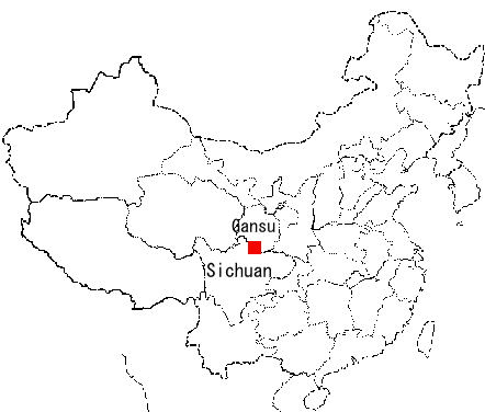
Endless grasslands upon scaling hills and mountains. A road slices through the landscape. |
 |
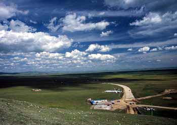
Countless numbers of grazing yak and sheep. Over-grazing has led to considerable environmental damage in some areas. |
 |
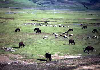
In a sea of stunning wild flowers, Chinese stellera (Stellera chamaejasme) stands out. A part of the Daphne family, not only is it used to de-worm livestock, but in traditional paper-making techniques as well. My travel companion Mr. Okada of Hokkaido noted, 'The paper-brush (Edgeworthia papyrifera) and campion (Diplomorpha sikokiana) used in Japanese traditional paper-making are also of the Daphne family. Fascinating! |
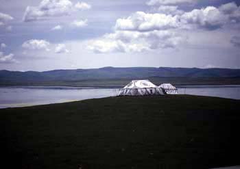 |
A tent housing a 'Tibetan cafeteria' overlooks Flower Lake at the Gahai-Zecha Nature Reserve. The surrounding grasslands were full of pika. We were able to view Black-necked Cranes on the opposite shore with a telescope. |
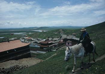 |
In the Yellow River's long journey from its fountainhead to the sea, it rounds 9 great curves. The very first curve is found within the Huanghe Shouqu Nature Reserve and is a popular site for tourism. The river can be seen off in the distant. The man on horseback is a local, and to the left the Tibetan monastery Sogcanggonba can be seen. I was able to see Himalayan Griffons(Gyps himalayensis) soaring above. |
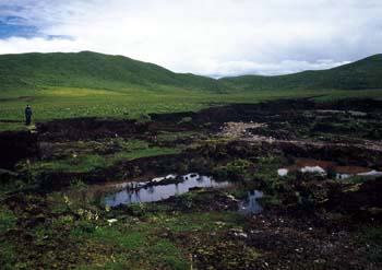 |
An abandoned peat extraction site. Large-scale operations are known to be directly devastating to the surrounding grasslands, resulting in the desiccation of the area. Peat was previously used for fuel purposes but now is largely extracted for use as fertilizer. On the net, I found a Japanese website touting, 'Indispensable for rooftop greenification…the king of soils: made of Chinese Sichuan highland peat.' I see. |
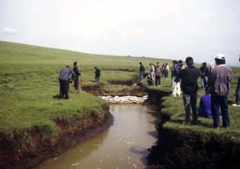 |
The formation of canals such as this one is a natural phenomenon found in wetlands. However, gradual deepening of these results in the drainage of water from surrounding areas, and thus their desiccation. Here, sandbags have been placed to curb drainage. |
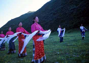 |
Flanked by Gansu and Sichuan Provinces lies the semi-autonomous region of Ruoergai, which is purely Tibetan. We were welcomed with song and dance by local youths bearing hada (lily white scarves of sheer silk), which is a Tibetan tradition. |
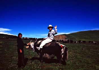 |
Yak can be used for transportation, as well as for its meat, milk, wool, and hide, making it truly an invaluable resource. Tibetans can ride yak with great skill, even reaching impressive speeds. The person on the yak is not a Tibetan, but me. They were not as large as I imagined they would be. |
| Photos and text: Nagai Hirokatsu | |
| *Unauthorized use of Photos and text is prohibited. |